ELEVATION GAIN: not much, about 100 feet on each loop
NO ROPES ARE REQUIRED--KIND OF LIKE MY TREKS TO VASQUEZ ROCKS PARK
Dogs are allowed here on leash
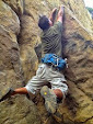
BELOW: THE LEDGE OF DOOM


DIRECTIONS TO TRAILHEAD: from Valley Circle Blvd. in the West San Fernando Valley, go uphill 2 miles on Woolsey canyon road and at top of hill, turn right at Sage Ranch sign, and the parking lot is on the left in 1/4 mile. Park in dirt lot next to the road. Parking is free here. (If you drive up the road inside the park to the top, you have to pay to park there. So don't unless you like giving the government your money)
MAP LINK TO TRAILHEAD AND PARKING: "A" is the parking lot
http://mapper.acme.com/?ll=34.23739,-118.65874&z=15&t=M&marker0=34.24128%2C-118.67172%2C4.1%20km%20WxNW%20of%20Chatsworth%20Reservoir%20CA
A PRINTABLE TRAILS, PARK BOUNDARY AND TOPO MAP IS HERE:
http://photos2.meetupstatic.com/photos/event/b/5/7/4/highres_77746452.jpeg
NOTE, THE EASTERN LOOP IS A BIT LONGER THAN ON THIS MAP, AS I'VE EXPLORED MORE OF THE EASTERN MESA SINCE MAKING THIS MAP

No comments:
Post a Comment