Expect 1/2 mile of creek bouldering on the route to Buckhorn Falls. We return to start and collect $200 by climbing up the slope to the left (east) of the falls and plunk down at the beautiful pools at the top of the falls. Then we quickly take a side trail back to the main trail to our cars.
DISTANCE: 7 miles
DIFFICULTY: MODERATE, 1100 feet elevation loss getting there, then 1100 feet elevation gain on the way back
BRING SHOES WITH GOOD GRIP THAT YOU CAN GET WET!!!
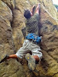
THERE ARE LOTS OF ROCKS TO CLIMB AND MONKEY AROUND UPON!!!!
PHOTOS: https://www.facebook.com/media/set/?set=a.10206569810670994.1073741870.1443226944&type=1&l=2b4a1a7fb9
http://www.meetup.com/hiking-196/photos/all_photos/?photoAlbumId=26096874
http://www.meetup.com/santamonicahikingclub/photos/all_photos/?photoAlbumId=1045755
VIDEOS:
https://www.facebook.com/rex.frankel/videos/10206953774389847/?l=2552925260220432819
https://www.facebook.com/video.php?v=10206569923673819&set=vb.1443226944&type=3&theater
https://www.facebook.com/video.php?v=10206569880472739&pnref=story

A stinky national forest restroom is at the Day Use Area. The camp has several restrooms and running water at various faucets.
GPS COORDINATES: N[masked] W[masked]
LINK TO PARKING MEETING SPOT (left marker)AND BURKHART TRAILHEAD (right marker):
http://mapper.acme.com/?ll=34.34736,-117.91276&z=16&t=M&marker0=34.34749%2C-117.91105%2C5.3%20km%20N%20of%20San%20Gabriel%20Mountains%20CA&marker1=34.34656%2C-117.92092%2C5.2%20km%20N%20of%20San%20Gabriel%20Mountains%20CA


PRINTABLE COOPER FALLS TRAILS MAP:
http://photos1.meetupstatic.com/photos/event/5/b/e/2/highres_129503522.jpeg

PRINTABLE TOPO MAP: http://photos1.meetupstatic.com/photos/event/a/f/3/4/highres_128564852.jpeg

No comments:
Post a Comment