Monkeying around, definition (Rex's dictionary): hiking plus assorted tomfoolery involving cool boulders and caves, providing a workout for both legs and arms, while our hike leader plays guitar and attempts to "sing" your favorite songs
-------------------------------------
IMPORTANT TRIVIA: Did you know that Sandstone Peak is not made of Sandstone? True. It is volcanic rock (Andesite/Basalt). Anyway, it is also called Mount Allen, named for the man who gave Circle X ranch to the Boy Scouts. It is also not made out of Mr. Allen. But that's just silly...
DISTANCE: 8.7 miles total
THE PLAN: We will start from the Mishe Mokwa trailhead and go 2 miles uphill to Sandstone Peak (elevation gain 900 feet), write naughty poems in the register book and EAT LUNCH while admiring the view. Below is the view at Sandstone Peak....Tri-Peaks is the middle and tallest of the peaks in the background

Then we continue another mile and a half to Tri-Peaks. We will climb up the northwest side, making good use of our grippy shoes. (NOTE: bring grippy shoes.) The rocks here are volcanic and have lots of handholds for easy climbing. Then we will go up and down and around and eventually find our way into a big room that has 4 entrances. However, it has no exits so we will be screwed. That's the end of the hike; we will now live here.
Oh yeah, if we do find our way out by walking backwards through the entrances, we will head to the crater in the middle of the peak. Next, we will pass through a tunnel to reach the top, enjoying the view and the overhang cave. Then we will finish at Tri-Peaks by walking through the 500 foot long by 4 foot wide and 30 foot deep crack (a fissure in the lava) back to where we started. It's very cool.
Then when we have come to our senses we will head back to our cars Up and mostly downhill the way we came.
---------------------MORE DETAILS ABOUT TRI-PEAKS:
Tri-Peaks is a volcanic mountain that shattered, leaving labyrinths, cracks and caves for we adventurers to explore.
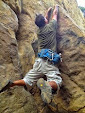
WE WILL SPEND 2 to 3 HOURS DOING A FULL CIRCLE CLIMB AROUND, UP, OVER, UNDER and THROUGH TRI-PEAKS. WE WILL CLIMB ROCKS THAT ARE SIMILAR TO THE ONES PICTURED ABOVE. BECAUSE IT IS SOLID VOLCANIC ROCK, IT HAS HAND AND FOOTHOLDS EVERYWHERE AND IS VERY EASY TO CLIMB--YES, YOU WILL NEED TO USE YOUR HANDS A LOT HERE.
BRING A FLASHLIGHT OR HEADLAMP FOR THE CAVE EXPLORATION

-----VIDEO of the hike: https://www.youtube.com/watch?v=607Iv3UaQo0

BELOW: CRACK ATTACK

DIFFICULTY LEVEL: moderate
THE PARK HAS A (totally arbitrary and silly) LIMIT OF 50 PEOPLE, AND 12 CARS MAXIMUM (National Park Service rules). So please carpool if possible. If you are the 51st person and/or in the 13th car, I am legally required to glare at you for a good long while.
-------------------------------
AMAZING PHOTOS (if I should say so myself):
http://www.meetup.com/hiking-196/photos/all_photos/?photoAlbumId=25450392
https://www.facebook.com/media/set/?set=a.10205351095363873.1073741847.1443226944&type=1&l=c1f690a7f4
-------------------------------
THERE IS NOT MUCH SHADE ON THIS HIKE.....BUT
EXPECTED WEATHER IS:
http://www.weather.com/weather/tenday/USCA0660
NEAREST POST-HIKE DINNER AND BEER-FEST PLACE: NEPTUNE'S NET (PCH and Yerba Buena Road).
------------------------------------------------------------
HOW TO GET THERE: it usually takes 1 and 1/2 hours to get here from central L.A..
(NOTE: DO NOT TAKE THIS ROUTE!!!!): If you like slow beach traffic: TAKE PACIFIC COAST HIGHWAY west to Yerba Buena Road. Turn right (uphill) and go around 6 miles. You will pass the Circle X Ranch ranger building. Continue on the road for another mile or so, past the parking lot with the Sandstone Peak Trailhead sign, to two dirt lots on either side of Yerba Buena Road. This is the Mishe Mokwa trailhead. Park here. Get out of your car.
OR: FROM L.A. TAKE THE 101 FREEWAY WEST TO THE KANAN DUME ROAD OFFRAMP. Turn Left. Take Kanan Dume south for several miles until you get to Mulholland Highway. Turn right. Very soon the road forks. Take the left fork, which is Encinal Canyon Road. Go a few more miles and at the "T", turn right onto Lachuza road. In a short distance, turn right onto Decker road. Continue 1 mile and turn left onto Mulholland Highway. In a 1/4 mile, a sudden right turn appears. This is Little Sycamore Road. Follow this twisty road for several more miles and with beautiful rock formations in the background, two dirt parking lots appear, one on each side of the road. WE MEET HERE!!!!! Some maps call this spot Triunfo Pass.
If you get to a big "Sandstone Peak" parking lot sign, you have gone too far. If you get to the Circle X ranch ranger station, you have really gone too far. Turn around!
---------------------------------------------------------------

PRINTABLE TRAILS AND PARKING LOCATION MAP:
http://photos4.meetupstatic.com/photos/event/3/4/c/8/highres_402853512.jpeg
Here are Google map directions from the 101 freeway at Kanan Dume Road (please try them, it took a lot of fiddling with the wacko Google maps direction system to make it):
https://www.google.com/maps/dir/34.1462937,-118.7611594/34.1145887,-118.9182564/@34.1346208,-118.8375307,11z/am=t/data=!4m4!4m3!1m0!1m0!3e0?hl=en

Were the caves hard to find around Tri Peaks Summit?
ReplyDeletenope. they are all over the north and east sides of the peak
ReplyDelete