then we collapse and eat snacks on the concrete pad up there with great views of the city and the ocean, then head downhill via the Stunt High Trail past Cold Creek back to our cars.
NOTE: you will use your hands a lot, along with your feet, on this climb. That's why I'm the monkey man.....
----------------
DISTANCE: 9 miles, 5 HOURS. Elevation gain is 1250 feet from Stunt Road to Topanga Lookout in mostly full sun.
Weather:
http://www.weather.com/weather/weekend/USCA0149
DIFFICULTY: The first three hours is a hard workout, but is doable by any able hiker. We will sometimes need to use our hands as we climb over rocks on the trail to Topanga Lookout. After lunch, the trail is much easier (more civilized).
PLEASE: NO DOGS, NOT EVEN ON-LEASH
PHOTOS: http://www.meetup.com/hiking-196/photos/all_photos/?photoAlbumId=4659602

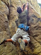
(BELOW: optional climb up this rock--the sane trail goes around it--this rock is suitable for thrillseekers only!)

(NOTE: sofas are not included)

(Topanga Lookout)
------------------------------
DIRECTIONS TO PARKING AREA:
Take the 101 freeway to the Woodland Hills area, and take the offramp to the SOUTHBOUND Topanga canyon Blvd.
In a mile, turn right onto Mulholland Drive. In a mile or so, you turn left onto Mulholland Highway. If you pass a Gelson's market shopping center, you took the correct turn.
Follow Mulholland Highway several more miles over the summit, then in a little more than a mile there is a hard right turn. Just before this turn is Stunt Road. Turn left onto Stunt road and go about 1 miles. PARK NEAR TRAIL CROSSING SIGN.
GOOGLE DIRECTIONS: https://maps.google.com/maps?saddr=Culver+City,+CA&daddr=1667+Stunt+Rd,+Calabasas,+CA&hl=en&sll=37.269174,-119.306607&sspn=11.21887,19.753418&geocode=FQIfBwIdzmnx-Cmdc3fbHrrCgDH-WetL0emFMQ%3BFUdACAIdl5Dt-Ck5CwC_jJ_CgDGydxCgrNQzYQ&t=m&mra=ls&z=12
BELOW: LOCATION OF PARKING

MAP TO THE PARKING--MEETUP SPOT:
http://mapper.acme.com/?ll=34.09507,-118.64852&z=15&t=M&marker0=34.09507%2C-118.64852%2C4.4%20km%20W%20of%20Topanga%20CA
PRINTABLE TRAIL MAPS:
http://photos3.meetupstatic.com/photos/event/d/a/3/6/highres_75595862.jpeg
http://photos3.meetupstatic.com/photos/event/2/c/9/4/highres_76571412.jpeg

No comments:
Post a Comment